
South Park Archaeology Project
 Setting
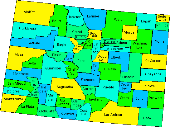
Geography: South Park (Park) is the center, literally, of Colorado. It is contained entirely within Park County.
To the north are Summit and Clear Creek Counties, south is Fremont County, while Jefferson and Teller Counties border on the east, and to the west are Chaffee and Lake Counties. The County seat is Fairplay which is situated in the northern portion of the Park; other communities in the Park include: Alma, Como, Hartsel, and Jefferson. The total population of Park County is approximately 15,000, although east-slope urbanites significantly inflate the population on weekends and holidays during the summer months and hunting season.
 The Park's surrounding peaks provide both impediments to human travel and opportunities.
Access to South Park from the eastern Front Range foothills and plains is provided
through several important passes and trails, especially the South Platte River and
Currant Creek corridors. Other passes and ancient trails provided routes of migration
and seasonal travel through Colorado's major intra-montane parks, from the San Luis
Valley and the Southern Rockies of New Mexico in the south (via Trout Creek and the
Arkansas River) and Middle Park, Rocky Mountain National Park, and North Park in the
north. The northern parks are accessed by several passes that cross and re-cross the
continental divide at different points.
The Park's surrounding peaks provide both impediments to human travel and opportunities.
Access to South Park from the eastern Front Range foothills and plains is provided
through several important passes and trails, especially the South Platte River and
Currant Creek corridors. Other passes and ancient trails provided routes of migration
and seasonal travel through Colorado's major intra-montane parks, from the San Luis
Valley and the Southern Rockies of New Mexico in the south (via Trout Creek and the
Arkansas River) and Middle Park, Rocky Mountain National Park, and North Park in the
north. The northern parks are accessed by several passes that cross and re-cross the
continental divide at different points.
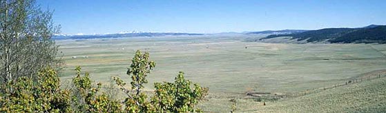
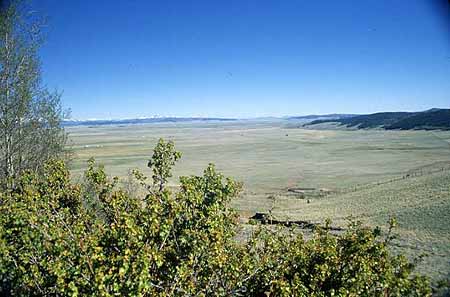
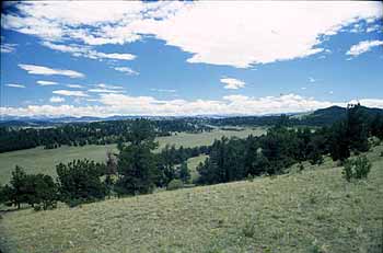
 Physiography:South Park is one of the largest, Colorado intermountain valleys. The Park is some
50 miles long, north to south, and 35 miles wide, east to west. Click on the image to the left to see a larger view of the park map.
Physiography:South Park is one of the largest, Colorado intermountain valleys. The Park is some
50 miles long, north to south, and 35 miles wide, east to west. Click on the image to the left to see a larger view of the park map.
Major mountain ranges that encircle the Park are the Mosquito Range to the west, portions of the Park Range and Front Range are to the north and northeast respectively, to the east are the Kenosha and Tarryall Mountains, and to the south are volcanic cinder cones and granite rock buttresses which form the divide between the South Platte and Arkansas Rivers.
The open grassland of the Park generally slopes from northwest (9,700 feet) to southeast (8,800 feet). The grassland is broken by numerous ridges (Reinecker, Mexican, Red Hill) which reach elevations over 10,000 feet.
 Glacial history: According to Stark et. al. (1949) in Geology and Origin of South Park, Colorado,
Pleistocene glaciation of the pre-Wisconsin Stage was quite extensive and evidence
for its existence is widespread throughout the Park. However, the actual glaciers
did not extend out of the mountains into the Park proper, although the Park landscape
was significantly modified by glacial melt-water stream-flows and its outwash sediments,
often reflected in river cut water gaps in ancient dinosaur-age hogback ridges and
tens of feet of silt, gravel, and cobble terrace deposits.
Glacial history: According to Stark et. al. (1949) in Geology and Origin of South Park, Colorado,
Pleistocene glaciation of the pre-Wisconsin Stage was quite extensive and evidence
for its existence is widespread throughout the Park. However, the actual glaciers
did not extend out of the mountains into the Park proper, although the Park landscape
was significantly modified by glacial melt-water stream-flows and its outwash sediments,
often reflected in river cut water gaps in ancient dinosaur-age hogback ridges and
tens of feet of silt, gravel, and cobble terrace deposits.
Wisconsin Stage (most recent) glaciation is not believed to have been as extensive as earlier stages as evidenced by the "drift" from the pre-Wisconsin stages that are found outside Wisconsin Stage moraines, indicating the greater extent of these older glaciers. However, much of the Park's existing surface owes its origin to reworking of these early moraines by outwash activity and windblown depositional processes. Colder-than-present Wisconsin Stage glaciation (from 70 to 12 thousand years ago) generally brought a strong alpine nature to the valley, but with only the mountains on the northwestern periphery of the Park actually subject to glacier ice. Stark states that, "the moraines barely reach the margins of the Park, but these outwash terraces cross the Park and end at the narrow gorges through which South Platte River and Tarryall Creek discharge."
Hydrology: South Park is drained by the South Platte River and Tarryall Creek. In addition, there are numerous named and unnamed, springs that dot the Park's generally dry landscape. Springs played a major role in the demographics of the Park's prehistoric past and continue to do so today.
Flora: The Park is an area of immense space, approximately 900 square miles. This high altitude enclosed basin is composed primarily of short grasses, forbs, and lichens.
The Park could be characterized as a mountain grassland dominated by the wheatgrass and needlegrass community. In addition, sagebrush, currant, and mountain mahogany occur as do many varieties of wild flowers and forbs. Many of the ridges within the Park contain large stands of bristlecone pine and aspen intermixed with Ponderosa pine. The surrounding mountains are blanketed by forests of western spruce and fir.
 Fauna: Historically, elk, mule deer, bison, and pronghorn antelope were the dominant large
game species in the Park. We also know that mammoth roamed the basin as evidenced
by the Como Mammoth site. We have observed all of the big game species except buffalo,
and have seen badger, coyote, and cottontail rabbits. We observed a variety of birds
including mountain plover, several species of raptors, Clark's nutcracker, magpie,
lark bunting, horned lark, and the ubiquitous sparrow.
Fauna: Historically, elk, mule deer, bison, and pronghorn antelope were the dominant large
game species in the Park. We also know that mammoth roamed the basin as evidenced
by the Como Mammoth site. We have observed all of the big game species except buffalo,
and have seen badger, coyote, and cottontail rabbits. We observed a variety of birds
including mountain plover, several species of raptors, Clark's nutcracker, magpie,
lark bunting, horned lark, and the ubiquitous sparrow.
Click on the images above to see larger views.