Senior Capstone Projects (2005-2006)
Caroline Bergelin and Jennifer Marks (2006)
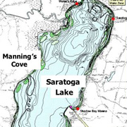
We used a survey to examine Saratoga Springs residents' views of proposals to develop new municipal water sources. Analysis of survey data show that recreational activities, household economics levels, and varying distances from Saratoga Lake influence how individuals value Saratoga Lake as a key aspect of environmental and social sustainability.
Elizabeth Brier-Rosenfield and Elizabeth King (2006)
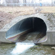
 Evaluating FEMA Flood Map Methodology and the implications of Flooding and Land Use
on Water Quality
Evaluating FEMA Flood Map Methodology and the implications of Flooding and Land Use
on Water Quality
Katie Bronson and Cortlandt Toczylowski (2006)
This project explored the methodology used to develop the 100 year FEMA flood map for the Saratoga Lake watershed and characterized land use patterns within this floodplain. We also assessed the possible influences of land use in the floodplain on the water quality of Saratoga Lake.
Full report is not available. Please contact Karen Kellogg for more information.
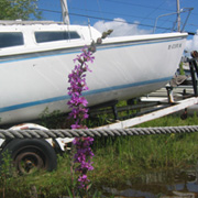
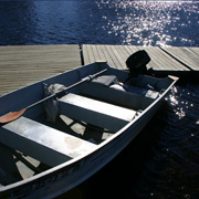 Boating and Fishing on Saratoga Lake: Stakeholders' Precieved Threats to Recreation
Ted Cavan, Christina Hanley, and Kate Sherman (2006)
Saratoga Lake is one of the top recreational destinations in the capital region. Our study focused on analysis of 15 semi-structured interviews of residents with a stake in boating and fishing activities on the lake. Findings include shared concerns about threats to recreation despite the lack of communication among stakeholders.
Full report is not available. Please contact Michael Ennis McMillan for more information.
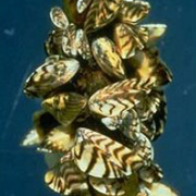 Effect of Zebra Mussels (Dreissena polymorpha) on Turbidity
Mary Dunham, Emily Voldstad, and Leanna Westfall(2006)
This study assessed how zebra mussels, an invasive species in Saratoga Lake, impact turbidity, which is a measure of water clarity. We also discuss interactions between zebra mussels and other invasive species, and how these relationships affect water quality in Saratoga Lake.
Full report is not available. Please contact Karen Kellogg for more information.
 Channelization in the Saratoga Lake Watershed
Allison Gillum and Allison Stafford (2006)
Using Geographical Information Systems (GIS) and field measurements, we determined the total length of streams in the Saratoga Lake watershed that have been channelized. While we found only approximately 5% to be channelized, primarily for transportation and industrial use, we discuss how these alterations could cause potential problems for the watershed.
 Natural and Human Influences on the Saratoga Lake Watershed: A Photographic Analysis
Josh Gerritsen and Adam Wallace (2006)
This project used photography to explore the natural and human influences on the Saratoga
Lake watershed. Starting at the headwaters of Kayaderosseras Creek and ending at the
Saratoga Lake outflow at Fish Creek, this exhibition provides a visual context for
understanding the competing interests that affect the surrounding watershed.
 Cultural Perceptions of Non-native Species in Saratoga Lake
Katie McClanahan and Christina Schull
We explored cultural perceptions of milfoil, water chestnuts, zebra mussels, and other pervading non-native species in Saratoga Lake and surrounding wetlands. We conducted open-ended semi-structured interviews with 15 informed individuals. Respondents reported both support and opposition for non-native species. We report on patterns of management, recreation, water quality, and ecology.
Full report is not available. Please contact Michael Ennis McMillan for more information.
Summer Collaborative Research (2006)
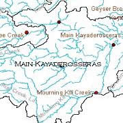 Water Quality Monitoring in the Kayaderosseras Creek and Saratoga Lake:Past, Present and Future
Kristina Connolly '07 and Judy Halstead, Department of Chemistry (2006)
The project has three related goals: collecting, reading and analyzing past sources of water quality data and monitoring in Saratoga Lake's watershed and surrounding regions, conducting a field and laboratory assessment of current water quality parameters in the tributaries of Saratoga Lake, and recommendations for future water quality monitoring projects.
Full report is not available. Please contact Judy Halstead for more information.
 Development on an Interactive Website for the Water Resources Initiative
Adam Wallace '06, Michael C. Ennis-McMillan, Department of Anthropology, Karen Kellogg, Department of Biology and Environmental Studies Program, and Alison Barnes, Department of English and Tang Teaching Museum and Art Gallery (2006)
This project consisted of designing an interactive and artistic website as an outreach and educational resource for the Water Resources Initiative. WRI is an interdisciplinary, community-based initiative that studies water issues in the local region. Each page of the website incorporates visual elements to create an engaging aesthetic that allows community members, Skidmore students and faculty, and local organizations to understand interactions in the Saratoga Lake watershed.
Full report is not available. Please contact Karen Kellogg for more information.
 Early Meanings of the Hudson River
Megan McAdams '08 and Rik Scarce, Department of Anthropology (2006)
From its discovery by Henry Hudson in 1609, the Hudson River landscape's meanings changed dramatically and repeatedly throughout history. Our project's goal was to develop a theory to describe the earliest of those shifting meanings and to explain the forces that gave rise to them. Our fundamental theoretical observation is that power, in some form, was dependent upon the Hudson River landscape. In that sense, the landscape, not human culture, was the ultimate arbiter of meaning in the Hudson's earliest recorded periods.
Full report is not available. Please contact Rik Scarce for more information.
 Water Conflicts and Contradictions: Recreation and Invasive Species in Saratoga Lake
Molly Bergen '06, Leah Wohl-Pollack '08, Michael Ennis-McMillan, Department of Anthropology, and Karen Kellogg, Department of Biology and Environmental Studies Program (2006)
Based on over forty interviews with informed county residents, we discovered that residents' perceptions of Saratoga Lake are influenced by their desire to protect their recreational interests, representing the economic and emotional value they place on Saratoga Lake. We also learned that personal interaction with invasive species influences residents' perceptions of which species are problematic and which species management plans are desirable. Our study indicates that personal interests often overshadow environmental concern for Saratoga Lake.
Full report is not available. Please contact Karen Kellogg for more information.
Independent Studies (2005-2006)
"Turbid" Waters of the Kayaderosseross: Human Caused or Glacially Influenced?
Erin E. Black '06 and Kyle K. Nichols, Department of Geosciences (2006)
The turbidity of streams can be caused by land use change, such as residential or commercial development and agricultural practices, or by natural erosion of stream banks. We measured stream discharge and turbidity in each watershed. Preliminary results show that discharge per unit area (Q/A) was controlled mostly by soil infiltration capacity and surficial geology, while residential and commercial development seemed to have little effect on the magnitude of Q/A. Our preliminary results suggest that farming practices increase stream turbidity, but the relationship between development and increased stream turbidity is less certain.
Full report is not available. Please contact Kyle Nichols for more information.
"In Depth " Knowledge (based on 378 well logs) of Kayaderosseross Creek Surficial Sediments
Michael Cleveland '06, Erin Black '06, Christine D'Esopo '07, Doug Donovan '06, Nicholas
Napoli, GIS Center for Interdisciplinary Research, and Kyle K. Nichols, Department
of Geosciences (2006)
Reinterpretation of 378 well logs provides a three-dimensional understanding of the
surficial sediments in the Kayaderosseras Creek watershed, which includes the proto-Hudson
River and the delta formed by its inlet into glacial Lake Albany. We utilized GIS
to produce a depth to bedrock map, define aquifer morphology and location, and identify
thickness of surficial sediment layers in the form of a three-dimensional block diagram.
We also produced isovel maps displaying depth to groundwater and water availability.
Full report is not available. Please contact Kyle Nichols for more information