Mapping past on present for local historians
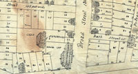
This 1810 map shows Gideon Putnam's
"Boarding House," "Bath House," a barn,
and stores.
How did a cemetery get onto my land? Why does that road bend so sharply? What is this schoolhouse doing in the middle of nowhere? City and county historians field such questions all the time. And lately, they’re getting help from Skidmore.
Each semester, economics professor Bob Jones assigns local-history projects as part of his course on geographic information systems, or GIS. Along with charting ethnic demographics and the political party of the incumbent in Congressional districts, incomes and unemployment rates in various regions, and other census data, his classes have traced land-use patterns over time, last year in Saratoga County and this year in nearby Washington County.
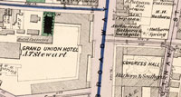
A georeferenced city map from 1876
shows the Grand Union Hotel in place
of Putnam's boarding house, and the
bathhouse is gone.
They started by unfurling and scanning old maps from town archives—or in the case of a late-1700s map that was too fragile to handle, photographing it in sections and tiling the photos together into one image. Then, in Skidmore's GIS lab (workstations running ArcGIS software, plus scanners, plotters, and other gear), Jones and students “georeferenced” the maps, matching geographic coordinates in order to precisely resize and superimpose maps from different eras. The resulting layers could show, for example, old roads, former businesses, new parklands, original land allotments, and current tax parcels. Viewed with GIS software, each map layer can be made as opaque or transparent as desired, and any segment of the map can be enlarged for a closer view.
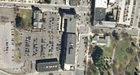
In this 2011 photo of the same neighbor-
hood, shops, condos, and parking lots
have replaced the hotel.
“Geography like this is putting history together,” Jones says. By adding environmental layers such as waterways, bedrock, and elevation, he explains, “We could tell a complete story. We could see how a sawmill was built on astream and the surrounding village remained even after the mill closed, or how a school building was abandoned and removed as the population center shifted and new schools were built.”
Marcella Jewell ’15, a double major in government and computer science, says, “This is a great course to take if you’re a visual learner.” She adds, “It’s been the most interdisciplinary class I've taken at Skidmore. It’s helpful for both my majors, but all students could benefit from learning to display their research in a visual manner.” In fact, Jones says, the GIS course over the past few years has enrolled students from 13 different majors, “whose mapping interests ranged from languages and dialects to Shakespeare play locations to historic stone walls. With creative use of layering—not to mention animations and virtual fly-overs—“your imagination is the only limitation to what you can do with GIS,” he says. “It’s really fun to teach.”
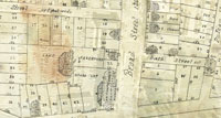
This overlay shows 2011's cars and
buildings under the semitransparent
map from 1810.
And it’s really useful too. Ron Feulner, town of Greenfield historian, says, “One of the most interesting mysteries I have been able to solve involved sorting the evolution of early highways, comparing maps to see how the roads changed.” He has to field questions from residents wondering why their property includes a tiny remnant cemetery (which, by law, they must keep accessible for visits by the descendants of those buried there), requests from the planning board to check for historic artifacts that may lie in the path of a development project, and more. Digitizing and uniformly scaling and sizing his archives’ original maps, Feulner says, means his work can take less time and less space.
Lately Jones and Alex Chaucer, Skidmore’s GIS instructional tech, have been helping county historians research software and hosting options for displaying interactive maps on their Web sites. Meanwhile, Jones is photographing historic sites, as well as videotaping historians’ narration, so that map viewers will be able to click on a spot and get pop-up content. Since his popular GIS course fills up every semester, there’s no end of opportunities to keep enriching local history.

